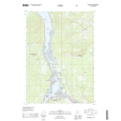
2017 Map of Petersburg C-3 NW
USGS Topo · Published 2017About this map
Wrangell Narrows serves as the central maritime corridor for this section of the Alaska Panhandle, separating the Lindenberg Peninsula from Mitkof Island. The complexity of the waterway is evident through numerous navigational hazards and landmarks, including the treacherous Colorado Reef, the debris-strewn California Boulder Patch, and the restrictive Halfway Anchorage. On the eastern shore, the Mitkof Highway provides land access parallel to the narrows, while the surrounding elevations of the Tongass National Forest are utilized for recreation via the Twin Ridge Ski Trail and Frenchy Ridge Snowmobile Trail. Significant coastal features such as Vexation Point and Danger Point reflect the historical challenges of piloting these waters, which remain vital for local transport and resource management.
Find a feature on this map
51 named features on this map. Tap any name to fly to it.
Don’t see what you’re looking for? This feature index may not catch every label — zoom into the map to look around manually.
Map Details
Editions of this 2017 Petersburg C-3 NW Map
This is the sole edition of this map. No revisions or reprints were ever made.
Other maps of this area

1948 · Petersburg C-4
USGS Topo · 1:63,360

1948 · Petersburg C-3
USGS Topo · 1:63,360

1951 · Petersburg D-4
USGS Topo · 1:63,360

1951 · Petersburg C-4
USGS Topo · 1:63,360

1952 · Petersburg
USGS Topo · 1:250,000

1953 · Petersburg C-3
USGS Topo · 1:63,360

1960 · Petersburg
USGS Topo · 1:250,000

1961 · Petersburg D-3
USGS Topo · 1:63,360
1992 · Petersburg D-4 SE
USGS Topo · 1:25,000
1992 · Petersburg C-3 SW
USGS Topo · 1:25,000