
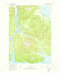
1953 Map of Petersburg C-3
USGS Topo · Published 1964About this map
Mitkof Island and the surrounding Alexander Archipelago waterways are captured here during a period of mid-century development within the Tongass National Forest. The map documents early industry and infrastructure, including the Alaska Experimental Fur Farm and a Power Plant situated along the winding Blind Slough. These features, alongside Papkes Landing, reflect the era's reliance on maritime access and specialized agriculture. Navigational challenges and coastal landmarks are meticulously noted, from the treacherous California Boulder Patch to named points like Vexation Pt and No Thorofare Pt. The presence of the Mitkof Highway indicates the growing terrestrial connectivity of the island, while settlements like Tonka on the Lindenberg Peninsula highlight the scattered nature of habitation along the Wrangell Narrows.
Find a feature on this map
47 named features on this map. Tap any name to fly to it.
Don’t see what you’re looking for? This feature index may not catch every label — zoom into the map to look around manually.
Map Details
Editions of this 1953 Petersburg C-3 Map
2 editions found
Other maps of this area

1948 · Petersburg C-4
USGS Topo · 1:63,360

1948 · Petersburg C-2
USGS Topo · 1:63,360

1948 · Petersburg B-2
USGS Topo · 1:63,360

1948 · Petersburg C-3
USGS Topo · 1:63,360

1948 · Petersburg B-3
USGS Topo · 1:63,360

1949 · Petersburg B-4
USGS Topo · 1:63,360

1951 · Petersburg B-4
USGS Topo · 1:63,360

1951 · Petersburg B-3
USGS Topo · 1:63,360

1951 · Petersburg D-4
USGS Topo · 1:63,360

1951 · Petersburg C-4
USGS Topo · 1:63,360