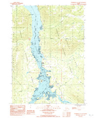
1992 Map of Petersburg C-3 NW
USGS Topo · Published 1992About this map
Wrangell Narrows serves as the central maritime artery of this coastal landscape, separating the Lindenberg Peninsula on Kupreanof Island from the shores of Mitkof Island. This 1990s-era topographical study highlights the navigational complexity of the waterway, dotted with features like Vexation Point, California Boulder Patch, and Halfmoon Anchorage. Coastal infrastructure is clustered primarily along the Mitkof Highway, including Papkes Landing and a nearby Fish Ladder. The map also documents the inland reach of the Tongass National Forest, showing the proximity of the Petersburg Corporate Boundary to the north. Historical sites such as Tonka (Site) and resource extraction points like the Quarry and Gravel Pit reflect the region's industrial footprint within the tidal flats and wooded gulches of the Alexander Archipelago.
Find a feature on this map
46 named features on this map. Tap any name to fly to it.
Don’t see what you’re looking for? This feature index may not catch every label — zoom into the map to look around manually.
Map Details
Editions of this 1992 Petersburg C-3 NW Map
This is the sole edition of this map. No revisions or reprints were ever made.
Other maps of this area

1948 · Petersburg C-4
USGS Topo · 1:63,360

1948 · Petersburg C-3
USGS Topo · 1:63,360

1951 · Petersburg D-4
USGS Topo · 1:63,360

1951 · Petersburg C-4
USGS Topo · 1:63,360

1952 · Petersburg
USGS Topo · 1:250,000

1953 · Petersburg C-3
USGS Topo · 1:63,360

1960 · Petersburg
USGS Topo · 1:250,000

1961 · Petersburg D-3
USGS Topo · 1:63,360
1992 · Petersburg D-4 SE
USGS Topo · 1:25,000
1992 · Petersburg C-3 SW
USGS Topo · 1:25,000