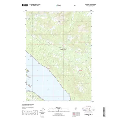
2017 Map of Petersburg C-4 NE
USGS Topo · Published 2017About this map
Kupreanof Island dominates this portion of the Alexander Archipelago, showing the wild coastal character of the Lindenberg Peninsula within the Tongass National Forest. The southwestern coastline is defined by the tidal reaches of Duncan Canal, where the terrain transitions from the water's edge into a network of drainage-based forest roads. The presence of routes like Mitchell-Tonka and Alpine indicates a landscape shaped by forest management and resource access. Small topographic details such as Siwash and various creek-aligned tracks including Brown Creek, Schia-De, and Gelch-De reveal the intricate layout of the interior hillsides above the canal. This map documents the intersection of maritime geography and federal forest lands in a region where travel is primarily dictated by the shoreline and established timber routes.
Find a feature on this map
15 named features on this map. Tap any name to fly to it.
Don’t see what you’re looking for? This feature index may not catch every label — zoom into the map to look around manually.
Map Details
Editions of this 2017 Petersburg C-4 NE Map
This is the sole edition of this map. No revisions or reprints were ever made.
Other maps of this area

1948 · Petersburg C-4
USGS Topo · 1:63,360

1948 · Petersburg C-3
USGS Topo · 1:63,360

1951 · Petersburg D-4
USGS Topo · 1:63,360

1951 · Petersburg C-4
USGS Topo · 1:63,360

1952 · Petersburg
USGS Topo · 1:250,000

1953 · Petersburg C-3
USGS Topo · 1:63,360

1960 · Petersburg
USGS Topo · 1:250,000

1961 · Petersburg D-3
USGS Topo · 1:63,360
1992 · Petersburg D-4 SE
USGS Topo · 1:25,000
1992 · Petersburg C-3 SW
USGS Topo · 1:25,000