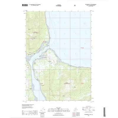
2017 Map of Petersburg D-3 SW
USGS Topo · Published 2017About this map
Petersburg occupies the northern tip of Mitkof Island, serving as a vital maritime hub along the Wrangell Narrows in the heart of the Tongass National Forest. This 2017 survey details the town's expansion toward Scow Bay and the infrastructure supporting its remote location, including the Petersburg James A Johnson Airport and water systems like the Petersburg Reservoir and Cabin Creek Reservoir. Across the narrows on the Lindenberg Peninsula, the small settlement of Kupreanof sits at the base of Kupreanof Island, isolated from the primary road network.
Find a feature on this map
47 named features on this map. Tap any name to fly to it.
Don’t see what you’re looking for? This feature index may not catch every label — zoom into the map to look around manually.
Map Details
Editions of this 2017 Petersburg D-3 SW Map
This is the sole edition of this map. No revisions or reprints were ever made.
Other maps of this area

1948 · Petersburg C-4
USGS Topo · 1:63,360

1948 · Petersburg C-3
USGS Topo · 1:63,360

1951 · Petersburg D-4
USGS Topo · 1:63,360

1951 · Petersburg C-4
USGS Topo · 1:63,360

1952 · Petersburg
USGS Topo · 1:250,000

1953 · Petersburg C-3
USGS Topo · 1:63,360

1960 · Petersburg
USGS Topo · 1:250,000

1961 · Petersburg D-3
USGS Topo · 1:63,360
1992 · Petersburg D-4 SE
USGS Topo · 1:25,000
1992 · Petersburg D-3 SW
USGS Topo · 1:25,000