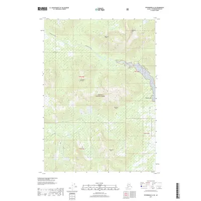
2017 Map of Petersburg D-4 SE
USGS Topo · Published 2017About this map
Kupreanof Island dominates this 2017 survey, showcasing the coastal wilderness of the Lindenberg Peninsula within the Tongass National Forest. The map details a landscape defined by significant water bodies and steep relief, anchored by the tidal reaches of Petersburg Creek and the high elevation of Del Monte Peak. To the north, the Petersburg Lake Trail meanders toward Petersburg Lake, providing a clear record of established access routes through the dense forest. In the southwest, a network of local forest roads such as Mitchell-Tonka, Trinket, and Henrietta indicates active land management and resource access. The small settlement of Kupreanof sits on the eastern shore, illustrating the character of isolated Alaskan coastal communities at the start of the twenty-first century.
Find a feature on this map
19 named features on this map. Tap any name to fly to it.
Don’t see what you’re looking for? This feature index may not catch every label — zoom into the map to look around manually.
Map Details
Editions of this 2017 Petersburg D-4 SE Map
This is the sole edition of this map. No revisions or reprints were ever made.
Other maps of this area

1948 · Petersburg C-4
USGS Topo · 1:63,360

1948 · Petersburg C-3
USGS Topo · 1:63,360

1951 · Petersburg D-4
USGS Topo · 1:63,360

1951 · Petersburg C-4
USGS Topo · 1:63,360

1952 · Petersburg
USGS Topo · 1:250,000

1953 · Petersburg C-3
USGS Topo · 1:63,360

1960 · Petersburg
USGS Topo · 1:250,000

1961 · Petersburg D-3
USGS Topo · 1:63,360
1992 · Petersburg D-4 SE
USGS Topo · 1:25,000
1992 · Petersburg D-3 SW
USGS Topo · 1:25,000