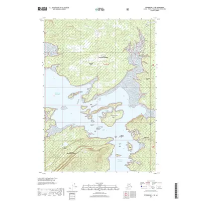
2017 Map of Petersburg D-6 SE
USGS Topo · Published 2017About this map
Kupreanof Island and Kuiu Island dominate this coastal landscape, separated by the complex marine passages of Keku Strait and Rocky Pass. This area within the Tongass National Forest is defined by its intricate shoreline, where numerous small landforms such as Horseshoe Island, Berry Island, and Beacon Island dot the waters of the Gulf of Alaska. The presence of the Big John Bay Trail near Big John Bay suggests a corridor for coastal access and exploration through the forest.
Find a feature on this map
22 named features on this map. Tap any name to fly to it.
Don’t see what you’re looking for? This feature index may not catch every label — zoom into the map to look around manually.
Map Details
Editions of this 2017 Petersburg D-6 SE Map
This is the sole edition of this map. No revisions or reprints were ever made.
Other maps of this area

1948 · Petersburg D-6
USGS Topo · 1:63,360

1948 · Petersburg C-6
USGS Topo · 1:63,360

1948 · Petersburg C-5
USGS Topo · 1:63,360

1948 · Petersburg D-5
USGS Topo · 1:63,360

1951 · Petersburg D-6
USGS Topo · 1:63,360

1951 · Petersburg C-5
USGS Topo · 1:63,360

1952 · Petersburg
USGS Topo · 1:250,000

1960 · Petersburg
USGS Topo · 1:250,000
1995 · Petersburg D-6
USGS Topo · 1:63,360
2017 · Petersburg C-5 NW
USGS Topo · 1:25,000