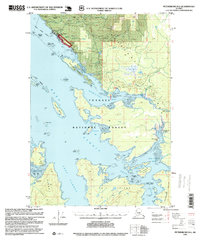
1995 Map of Petersburg D-6
USGS Topo · Published 1999About this map
The coastal village of Kake serves as the primary hub on the northwestern tip of Kupreanof Island, where the Alaska Marine Highway connects this Tlingit community to the broader region. This mid-1990s revision reveals a landscape shaped by both traditional maritime life and industrial timber operations, evidenced by the Logging Camp Work Center near Portage Bay and a Log Transfer Facility situated on Little Hamilton Island. The surrounding waters of Keku Strait and Hamilton Bay are dotted with landmarks of local industry, including a private Fish Hatchery, a Cannery, and numerous Oil Tanks near the waterfront.
Find a feature on this map
57 named features on this map. Tap any name to fly to it.
Don’t see what you’re looking for? This feature index may not catch every label — zoom into the map to look around manually.
Map Details
Editions of this 1995 Petersburg D-6 Map
This is the sole edition of this map. No revisions or reprints were ever made.
Other maps of this area

1948 · Port Alexander C-1
USGS Topo · 1:63,360

1948 · Sumdum A-5
USGS Topo · 1:63,360

1948 · Sumdum A-6
USGS Topo · 1:63,360

1948 · Petersburg D-6
USGS Topo · 1:63,360

1948 · Port Alexander D-1
USGS Topo · 1:63,360

1948 · Petersburg C-6
USGS Topo · 1:63,360

1948 · Sitka A-1
USGS Topo · 1:63,360

1948 · Petersburg C-5
USGS Topo · 1:63,360

1948 · Petersburg D-5
USGS Topo · 1:63,360

1951 · Sitka
USGS Topo · 1:250,000