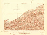
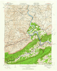
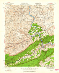
1932 Map of Peterstown
USGS Topo · Published 1932About this map
New River carves a deep path through the Appalachians in this early 1930s survey, where the border between West Virginia and Virginia follows the crest of Peters Mountain. The town of Narrows serves as a critical junction where the Norfolk and Western and Virginian lines navigate the river gap. The landscape is defined by its industrial transit and remote mountain communities, seen in the string of small stops like Penvir and Pearisburg Sta along the water's edge.
Find a feature on this map
33 named features on this map. Tap any name to fly to it.
Don’t see what you’re looking for? This feature index may not catch every label — zoom into the map to look around manually.
Map Details
Editions of this 1932 Peterstown Map
3 editions found
Other maps of this area

1887 · Pocahontas
USGS Topo · 1:125,000

1887 · Hinton
USGS Topo · 1:125,000

1890 · Dublin
USGS Topo · 1:125,000

1891 · Pocahontas
USGS Topo · 1:125,000

1891 · Dublin
USGS Topo · 1:125,000

1891 · Raleigh
USGS Topo · 1:125,000

1892 · Hinton
USGS Topo · 1:125,000

1894 · Pocahontas
USGS Topo · 1:125,000

1895 · Pocahontas
USGS Topo · 1:125,000

1897 · Raleigh
USGS Topo · 1:125,000