
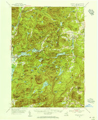
1973 Map of Pharaoh Mountain
USGS Topo · Published 1976About this map
Pharaoh Mountain dominates the center of this landscape, its summit marked by a Lookout Tower overlooking the vast Adirondack State Park. The terrain is defined by a dense network of high-elevation water bodies and marshes, from the sprawling Pharaoh Lake in the southeast to the smaller Coffee Pond and Goose Pond. Human presence is concentrated along the western edge near Severance and the Schroon River, where the Schroon Lake Airport and Sandpit Cem reside.
Find a feature on this map
79 named features on this map. Tap any name to fly to it.
Don’t see what you’re looking for? This feature index may not catch every label — zoom into the map to look around manually.
Map Details
Editions of this 1973 Pharaoh Mountain Map
This is the sole edition of this map. No revisions or reprints were ever made.
Other maps of this area

1895 · North Creek
USGS Topo · 1:62,500

1895 · Paradox Lake
USGS Topo · 1:62,500

1897 · Bolton
USGS Topo · 1:62,500

1897 · Paradox Lake
USGS Topo · 1:62,500

1897 · North Creek
USGS Topo · 1:62,500

1897 · Schroon Lake
USGS Topo · 1:62,500

1900 · Bolton
USGS Topo · 1:62,500

1950 · Glens Falls
USGS Topo · 1:250,000
1953 · Paradox Lake
USGS Topo · 1:62,500
1953 · Schroon Lake
USGS Topo · 1:62,500