
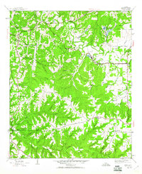
1936 Map of Phil Campbell
USGS Topo · Published 1936About this map
Phil Campbell serves as the primary hub of this 1936 survey, situated at the junction of State Highway No 5 and the Southern Railway. This era in Northwest Alabama was defined by a mix of forestry and extractive industry, evidenced by the Alabama National Forest boundary and mining operations such as Lowler Mines and Hager Mine. The landscape is characterized by the winding path of Bear Creek, which supported local industry through the Davis Mill Dam.
Find a feature on this map
67 named features on this map. Tap any name to fly to it.
Don’t see what you’re looking for? This feature index may not catch every label — zoom into the map to look around manually.
Map Details
Editions of this 1936 Phil Campbell Map
This is the sole edition of this map. No revisions or reprints were ever made.
Other maps of this area

1936 · Newburg
USGS Topo · 1:24,000

1936 · Delmar
USGS Topo · 1:24,000

1936 · Kinlock Spring
USGS Topo · 1:24,000

1936 · Isbell
USGS Topo · 1:24,000

1936 · South Of Hackleburg
USGS Topo · 1:24,000

1936 · Hackleburg
USGS Topo · 1:24,000

1936 · Spruce Pine
USGS Topo · 1:24,000

1936 · Goddard
USGS Topo · 1:24,000

1945 · Spruce Pine
USGS Topo · 1:24,000
1945 · Isbell
USGS Topo · 1:24,000