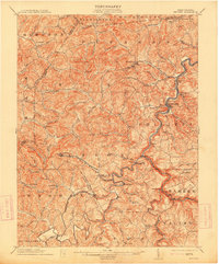
1925 Map of Philippi
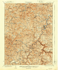
USGS Topo · Published 1954About this map
The Tygart River winds through the heart of Barbour County, anchoring a landscape where coal mining and rural life intersected in the mid-1920s. Centered on the historic seat of Philippi, the map captures the community before modern development, showing the importance of the Baltimore and Ohio RR as it follows the river valley to serve industrial outposts like Century and Galloway. Small hamlets such as Berryburg and Meriden are shown at their height, supported by an extensive network of country schoolhouses like Pigtail School and Mudlick School.
Find a feature on this map
144 named features on this map. Tap any name to fly to it.
Don’t see what you’re looking for? This feature index may not catch every label — zoom into the map to look around manually.
Map Details
Editions of this 1925 Philippi Map
This is the sole edition of this map. No revisions or reprints were ever made.
Historical Maps of Buckhannon Through Time
5 maps found