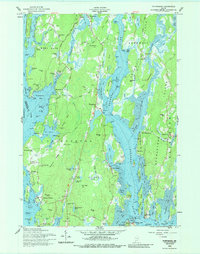
1957 Map of Phippsburg
USGS Topo · Published 1988About this map
The coastal peninsula of Phippsburg and the winding Kennebec River dominate this mid-century portrait of coastal Maine. In the south, the strategic entrance to the river is guarded by Fort Baldwin US Mil Res and Fort Popham, illustrating the area's long-standing maritime defense significance. The landscape is a complex network of tidal inlets like Winnegance Bay and Atkins Bay, where small settlements such as Ashdale, Marrtown, and Sebasco are connected by narrow roads like the High Road and Popham Road.
Find a feature on this map
121 named features on this map. Tap any name to fly to it.
Don’t see what you’re looking for? This feature index may not catch every label — zoom into the map to look around manually.
Map Details
Editions of this 1957 Phippsburg Map
2 editions found
Other maps of this area

1893 · Small Point
USGS Topo · 1:62,500

1893 · Boothbay
USGS Topo · 1:62,500

1894 · Bath
USGS Topo · 1:62,500

1919 · Small Point
USGS Topo · 1:62,500

1920 · Bath
USGS Topo · 1:62,500

1941 · Boothbay
USGS Topo · 1:62,500

1943 · Boothbay
USGS Topo · 1:62,500

1944 · Boothbay
USGS Topo · 1:62,500

1944 · Small Point
USGS Topo · 1:62,500

1945 · Bath
USGS Topo · 1:62,500