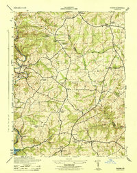
1944 Map of Phoenix
USGS Topo · Published 1944About this map
My Ladys Manor anchors this northern Maryland landscape, a historic land grant area where the Baltimore County and Harford County lines meet. The terrain is defined by the winding course of Gunpowder Falls and its many tributaries, including Little Falls and Yellow Branch. The Pennsylvania railroad corridor tracks the river valley, serving rural settlements like Monkton and Corbett. This mid-century survey reveals a deeply established community of country churches and schools, such as Clynmalira Church, Chestnut Grove Church, and the Shepperd School. At the southern edge, the rising waters of the Loch Raven Reservoir signal the region's role in the metropolitan water system. Notable local landmarks like the Elkridge-Harford Hunt Club and the My Ladys Manor Mill reflect the area's long-standing equestrian and milling heritage.
Find a feature on this map
53 named features on this map. Tap any name to fly to it.
Don’t see what you’re looking for? This feature index may not catch every label — zoom into the map to look around manually.
Map Details
Editions of this 1944 Phoenix Map
This is the sole edition of this map. No revisions or reprints were ever made.
Other maps of this area

1893 · Gunpowder
USGS Topo · 1:62,500

1894 · Baltimore
USGS Topo · 1:62,500

1898 · Tolchester
USGS Topo · 1:125,000

1899 · Baltimore
USGS Topo · 1:62,500

1900 · Parkton
USGS Topo · 1:62,500

1901 · Belair
USGS Topo · 1:62,500

1901 · Gunpowder
USGS Topo · 1:62,500

1902 · Parkton
USGS Topo · 1:62,500

1903 · Tolchester
USGS Topo · 1:125,000

1904 · Baltimore
USGS Topo · 1:62,500