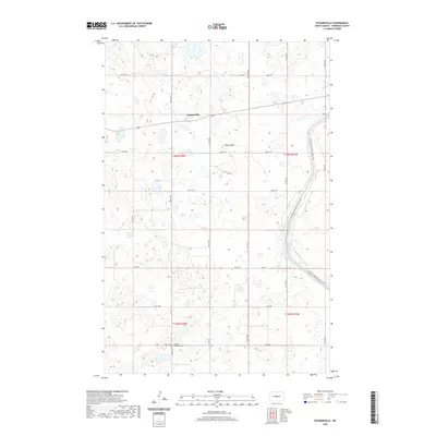
2020 Map of Pickardville
USGS Topo · Published 2020About this map
Pickardville sits at the heart of this Sheridan County landscape, where the prairie is defined by a complex network of wetlands and small water bodies. The terrain features local landmarks like Klinks Slope, a rise in the land south of the main settlement. A significant modern engineering feature, the McClusky Canal, cuts through the southeastern portion of the map, closely followed by the route of the N Country National Scenic Trail. For those tracing local history or family roots, the Edgmont Township Cem is situated in the southern portion of the quadrangle near the boundary of T145N and T146N. The map's grid-based road system, including Main St and several numbered streets, illustrates the structured rural development of this North Dakota region.
Find a feature on this map
22 named features on this map. Tap any name to fly to it.
Don’t see what you’re looking for? This feature index may not catch every label — zoom into the map to look around manually.
Map Details
Editions of this 2020 Pickardville Map
This is the sole edition of this map. No revisions or reprints were ever made.
Other maps of this area

1945 · Pelican Lake
USGS Topo · 1:62,500

1947 · Pelican Lake
USGS Topo · 1:62,500

1947 · Lincoln Valley
USGS Topo · 1:62,500

1954 · McClusky
USGS Topo · 1:250,000

1958 · McClusky
USGS Topo · 1:250,000

1959 · Pickardville
USGS Topo · 1:24,000

1959 · Mercer
USGS Topo · 1:24,000

1959 · Mercer SW
USGS Topo · 1:24,000

1959 · Mercer SE
USGS Topo · 1:24,000

1959 · McClusky
USGS Topo · 1:24,000