
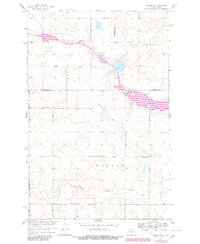
1959 Map of Mercer SW
USGS Topo · Published 1960About this map
Heckers Lake and the winding course of Painted Woods Creek anchor this prairie landscape along the intersection of Burleigh, McLean, and Sheridan Counties. Surveyed for the development of the Missouri River Basin, the map reveals a rural settlement pattern defined by numbered school districts and country cemeteries. The terrain transitions between the Edgemont and Wilson townships, where small water bodies and wetlands dot the upland prairie. Local genealogy and land-use history are preserved through features like the Bethel Cem and scattered educational hubs such as Park Sch No 2, School No 1, and School No 5. A lone Gravel Pit near the creek drainage points to the local material extraction necessary for maintaining the network of unimproved dirt and light-duty roads that connected these isolated homesteads during the late 1950s.
Find a feature on this map
14 named features on this map. Tap any name to fly to it.
Don’t see what you’re looking for? This feature index may not catch every label — zoom into the map to look around manually.
Map Details
Editions of this 1959 Mercer SW Map
2 editions found
Other maps of this area

1949 · Turtle Creek
USGS Topo · 1:62,500

1950 · Wilton
USGS Topo · 1:62,500

1954 · McClusky
USGS Topo · 1:250,000

1958 · McClusky
USGS Topo · 1:250,000

1959 · Pickardville
USGS Topo · 1:24,000

1959 · Mercer
USGS Topo · 1:24,000

1959 · Mercer SE
USGS Topo · 1:24,000

1961 · Turtle Creek NE
USGS Topo · 1:24,000

1961 · Turtle Creek SE
USGS Topo · 1:24,000
1966 · Wilton
USGS Topo · 1:24,000