
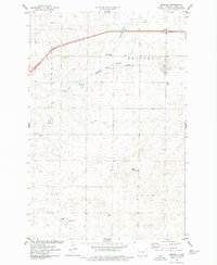
1971 Map of Moffit
USGS Topo · Published 1973About this map
Long Lake dominates this central North Dakota landscape, its waters and surrounding shoreline protected as part of the National Wildlife Refuge. The small settlement of Moffit serves as the focal point for this rural area, situated at the intersection of a Burlington Northern rail line and Highway 83. The terrain transitions from the marshy lowlands of Long Creek to the distinct prominence of Moffit Butte to the east. Evidence of the early 1970s local infrastructure is found in the scattered Gravel Pits and the Moffit Cemetery located just south of town. The southern portion of the map reveals the open landscape of the Buchanan Valley, highlighting the characteristic township and section grid that defines the Great Plains. Industrial and transportation signatures are visible through the dual presence of the Soo Line and Burlington Northern railroads, which historically shaped the region's agricultural economy.
Find a feature on this map
21 named features on this map. Tap any name to fly to it.
Don’t see what you’re looking for? This feature index may not catch every label — zoom into the map to look around manually.
Map Details
Editions of this 1971 Moffit Map
This is the sole edition of this map. No revisions or reprints were ever made.
Other maps of this area

1951 · McKenzie
USGS Topo · 1:62,500

1951 · Driscoll
USGS Topo · 1:62,500

1954 · Bismarck
USGS Topo · 1:250,000

1958 · Bismarck
USGS Topo · 1:250,000

1971 · Moffit SW
USGS Topo · 1:24,000

1971 · Moffit SE
USGS Topo · 1:24,000

1971 · Moffit NW
USGS Topo · 1:24,000

1975 · McKenzie
USGS Topo · 1:24,000

1975 · Sterling
USGS Topo · 1:24,000
1975 · Driscoll
USGS Topo · 1:24,000