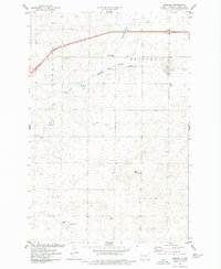
1975 Map of Driscoll
USGS Topo · Published 1977About this map
Driscoll sits as the central hub of this Burleigh County landscape during the mid-1970s, where the Burlington Northern railroad corridor and a major pipeline cross the prairie. The settlement pattern is defined by rural townsite plats and dispersed homesteads, including the smaller locale of Trautman to the south. Local heritage is grounded in landmarks like the Driscoll Cem and the recreational space at Driscoll Sibley Park, while the geography is shaped by water features such as Cottonwood Lake, Random Slough, and Random Creek. Numerous Gravel Pits suggest an active local extraction industry supporting the roads and rail lines that connect this region of North Dakota. The map captures the transition of the Great Plains environment, where natural hydrology meets industrial infrastructure.
Find a feature on this map
17 named features on this map. Tap any name to fly to it.
Don’t see what you’re looking for? This feature index may not catch every label — zoom into the map to look around manually.
Map Details
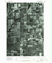
Editions of this 1975 Driscoll Map
2 editions found
Other maps of this area

1951 · McKenzie
USGS Topo · 1:62,500

1951 · Driscoll
USGS Topo · 1:62,500

1954 · Bismarck
USGS Topo · 1:250,000

1958 · Bismarck
USGS Topo · 1:250,000

1971 · Moffit
USGS Topo · 1:24,000

1975 · Sibley Butte
USGS Topo · 1:24,000

1975 · Sterling
USGS Topo · 1:24,000

1975 · Lake Geneva
USGS Topo · 1:24,000
1975 · Stony Slough
USGS Topo · 1:24,000
1975 · Clear Lake
USGS Topo · 1:24,000