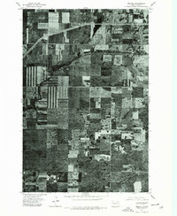
1975 Map of Driscoll
USGS Topo · Published 1977About this map
Driscoll serves as the focal point of this orthophotomap, showing the town's small-scale street grid and rural layout as it existed in the mid-1970s. The aerial imagery highlights a high-contrast patchwork of agricultural activity, with many fields displaying distinctive strip-cropping patterns designed to manage soil erosion on the North Dakota plains. A primary transportation corridor, including a prominent rail line and highway, cuts through the northern portion of the quadrangle, linking the town to the broader regional economy. While the settlement itself is compact, the surrounding landscape is defined by scattered farmsteads and numerous small prairie potholes, reflecting the unique glacial topography of the area. This 1975 survey captures a specific moment in the agrarian development of Burleigh County, documenting the exact footprint of land use and rural infrastructure before modern changes.
Find a feature on this map
1 named feature on this map. Tap any name to fly to it.
Don’t see what you’re looking for? This feature index may not catch every label — zoom into the map to look around manually.
Map Details
Editions of this 1975 Driscoll Map
2 editions found
Other maps of this area

1951 · McKenzie
USGS Topo · 1:62,500

1951 · Driscoll
USGS Topo · 1:62,500

1954 · Bismarck
USGS Topo · 1:250,000

1958 · Bismarck
USGS Topo · 1:250,000

1971 · Moffit
USGS Topo · 1:24,000

1975 · Sibley Butte
USGS Topo · 1:24,000

1975 · Sterling
USGS Topo · 1:24,000

1975 · Lake Geneva
USGS Topo · 1:24,000
1975 · Stony Slough
USGS Topo · 1:24,000
1975 · Clear Lake
USGS Topo · 1:24,000