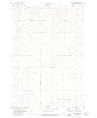
1975 Map of Stony Slough
USGS Topo · Published 1977About this map
Stony Slough defines the southern drainage of this prairie landscape at the boundary of Kidder and Burleigh counties. The mid-1970s terrain is marked by the expansive township divisions of Lein, Chestina, Clear Lake, Excelsior, Driscoll, and Pleasant Hill. These jurisdictions reveal a highly organized agrarian grid, where fine red dashed lines indicate the field and fence lines visible from aerial photography during the survey period. A small-scale industrial presence is noted via a Gravel Pit located near the county line, while a Radio Tower in the northwest corner serves as a prominent vertical landmark in the flat topography. The map illustrates a moment in North Dakota's geography after the primary settlement era but before significant modern consolidation, preserving the specific placement of rural infrastructure and water features.
Find a feature on this map
11 named features on this map. Tap any name to fly to it.
Don’t see what you’re looking for? This feature index may not catch every label — zoom into the map to look around manually.
Map Details
Editions of this 1975 Stony Slough Map
This is the sole edition of this map. No revisions or reprints were ever made.
Other maps of this area

1951 · Driscoll
USGS Topo · 1:62,500

1952 · Steele
USGS Topo · 1:24,000

1952 · Steele NW
USGS Topo · 1:24,000

1952 · New Rockford
USGS Topo · 1:250,000

1953 · Jamestown
USGS Topo · 1:250,000

1954 · Bismarck
USGS Topo · 1:250,000

1954 · McClusky
USGS Topo · 1:250,000

1956 · New Rockford
USGS Topo · 1:250,000

1956 · Jamestown
USGS Topo · 1:250,000

1958 · Bismarck
USGS Topo · 1:250,000