
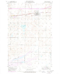
1952 Map of Steele
USGS Topo · Published 1954About this map
The Steele townsite serves as the central hub of this Kidder County landscape, situated along the Northern Pacific railroad. The surrounding terrain is characterized by a high density of small water bodies and wetlands typical of the Missouri Coteau region, including Weber Lake and the substantial waters of Long Lake. The southern portion of the map is dominated by the Long Lake National Wildlife Refuge, established to protect this critical migratory bird habitat. Local life in the early 1950s is anchored by rural institutions like School No 2 and School No 3. Distinctive landforms such as Pleasant Hill, Crown Hill, and Woodlawn provide elevation markers across the prairie, while a Gravel Pit near the railroad tracks indicates the local importance of aggregate mining for infrastructure during this era of post-war development.
Find a feature on this map
17 named features on this map. Tap any name to fly to it.
Don’t see what you’re looking for? This feature index may not catch every label — zoom into the map to look around manually.
Map Details
Editions of this 1952 Steele Map
2 editions found
Other maps of this area

1951 · Driscoll
USGS Topo · 1:62,500

1952 · Dawson
USGS Topo · 1:24,000

1952 · Steele NE
USGS Topo · 1:24,000

1952 · Steele NW
USGS Topo · 1:24,000

1953 · Jamestown
USGS Topo · 1:250,000

1954 · Bismarck
USGS Topo · 1:250,000

1956 · Jamestown
USGS Topo · 1:250,000

1958 · Bismarck
USGS Topo · 1:250,000

1975 · Lake Geneva
USGS Topo · 1:24,000
1975 · Stony Slough
USGS Topo · 1:24,000