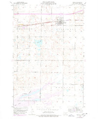
1952 Map of Steele
USGS Topo · Published 1978About this map
Steele sits as the central hub of this Kidder County landscape, positioned along the vital east-west corridor of the Northern Pacific railroad. The map reveals a post-war rural environment where local education was still decentralized, as evidenced by School No 2 and School No 3 serving the surrounding agricultural townships. A small Landing Strip northwest of the town center points to the early adoption of private aviation in the northern plains during the mid-century era.
Find a feature on this map
16 named features on this map. Tap any name to fly to it.
Don’t see what you’re looking for? This feature index may not catch every label — zoom into the map to look around manually.
Map Details
Editions of this 1952 Steele Map
2 editions found
Other maps of this area

1951 · Driscoll
USGS Topo · 1:62,500

1952 · Dawson
USGS Topo · 1:24,000

1952 · Steele NE
USGS Topo · 1:24,000

1952 · Steele
USGS Topo · 1:24,000

1952 · Steele NW
USGS Topo · 1:24,000

1953 · Jamestown
USGS Topo · 1:250,000

1954 · Bismarck
USGS Topo · 1:250,000

1956 · Jamestown
USGS Topo · 1:250,000

1958 · Bismarck
USGS Topo · 1:250,000

1975 · Lake Geneva
USGS Topo · 1:24,000