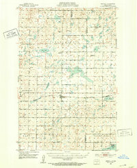
1951 Map of Driscoll
USGS Topo · Published 1953About this map
Driscoll sits at the heart of this prairie landscape, serving as a hub for the surrounding agricultural townships of Sterling, Driscoll, and Pleasant Hill. The area's social fabric is evidenced by a dense network of local landmarks, including the Town Hall, Zion Ch, and numerous rural schoolhouses such as White Sch No 1. The map reveals a land defined by its glacial hydrology, with Magnuson Lake, Clear Lake, and Lake Geneva dotting the plains. In the southern portion, the Long Lake National Wildlife Refuge marks a significant conservation area. Historical depth is provided by the Chaska Historic Site, located north of the Stony Slough. The Pacific Northern railroad tracks cut across the terrain, paralleling the primary roads and connecting these isolated farmsteads to the wider region.
Find a feature on this map
33 named features on this map. Tap any name to fly to it.
Don’t see what you’re looking for? This feature index may not catch every label — zoom into the map to look around manually.
Map Details
Editions of this 1951 Driscoll Map
This is the sole edition of this map. No revisions or reprints were ever made.
Other maps of this area
1951 · McKenzie
USGS Topo · 1:62,500
1952 · Steele
USGS Topo · 1:24,000
1952 · Steele NW
USGS Topo · 1:24,000

1952 · New Rockford
USGS Topo · 1:250,000

1953 · Jamestown
USGS Topo · 1:250,000

1954 · Bismarck
USGS Topo · 1:250,000

1954 · McClusky
USGS Topo · 1:250,000

1956 · New Rockford
USGS Topo · 1:250,000

1956 · Jamestown
USGS Topo · 1:250,000

1958 · Bismarck
USGS Topo · 1:250,000