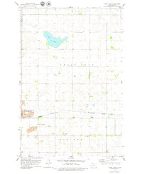
1979 Map of Grass Lake
USGS Topo · Published 1979About this map
Grass Lake sits at the center of this rural landscape along the Mc Lean and Burleigh County border in the late 1970s. The region is defined by a legacy of resource extraction and rail transport, evidenced by the expansive Strip Mine operations and the Wilton Mine State Game Management Area. The Burlington Northern railroad cuts through the southern portion of the map, passing the small settlement of Still, while an Old Railroad Grade to the south reflects an earlier era of transport infrastructure.
Find a feature on this map
17 named features on this map. Tap any name to fly to it.
Don’t see what you’re looking for? This feature index may not catch every label — zoom into the map to look around manually.
Map Details
Editions of this 1979 Grass Lake Map
This is the sole edition of this map. No revisions or reprints were ever made.
Other maps of this area

1949 · Turtle Creek
USGS Topo · 1:62,500

1950 · Wilton
USGS Topo · 1:62,500

1954 · McClusky
USGS Topo · 1:250,000

1958 · McClusky
USGS Topo · 1:250,000

1959 · Mercer SW
USGS Topo · 1:24,000

1959 · Mercer SE
USGS Topo · 1:24,000

1961 · Turtle Creek SE
USGS Topo · 1:24,000

1966 · Wilton SE
USGS Topo · 1:24,000
1966 · Wilton
USGS Topo · 1:24,000
1975 · Regan SE
USGS Topo · 1:24,000