Old Maps of McLean County, North Dakota
Explore 419 old maps of McLean County, spanning from 1922 to today. These high-resolution historic maps reveal how streets, neighborhoods, landmarks, and natural features evolved over time — perfect for genealogy, metal detecting, research, and local history exploration.
What you can do with these maps:
- See how McLean County changed over time: Compare historical maps to modern-day views to trace roads, homesites, rail lines & more.
- View detailed metadata: Each map includes creators, publishers, year, scale, and archive source.
- Overlay maps with satellite & LiDAR: Visualize the past alongside modern tools to explore terrain & human change.
- Trusted historical sources: Maps sourced from the USGS, Library of Congress, and other archives.
- Access maps your way: View online, download high-res files, or order prints for personal or research use.
Start exploring old maps of McLean County to uncover forgotten places, hidden landmarks, and the deep history beneath your feet.
McLean County, ND maps
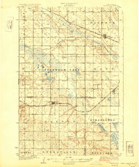
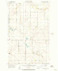
(419)- 1922 Map of Garrison
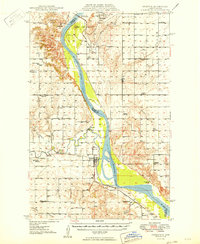
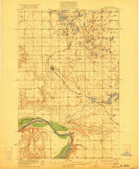 1922 Garrison1922 Print · USGSIn the early 1920s, McLean County was a landscape of steam-powered transit and scattered prairie schoolhouses. Researchers can trace the original Soo Line rail corridor and locate rural landmarks like Ireland School, Baker School, and the winding Snake Creek valley.2 unique versions available
 - 1929 Map of Coleharbor
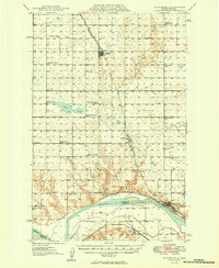
 1929 Coleharbor1929 Print · USGSMcLean County townships are shown here during the late 1920s as the rail network solidified the region's agricultural economy. Genealogists and local historians can locate early prairie schoolhouses like Fisher Sch and trace the original route of the Minneapolis St Paul and Sault Ste Marie railroad.3 unique versions available
 - 1929 Map of Benedict
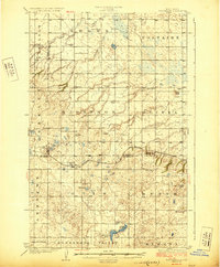
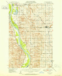
 1929 Benedict1929 Print · USGSThe North Dakota prairie near the McLean and Ward county line is captured here in the late twenties, centered on the rail-stop of Benedict. Researchers can locate numerous early schoolhouses and trace the path of the Minneapolis St Paul and Sault Ste Marie through Poplar and Greeley.3 unique versions available
 - 1929 Map of Kongsberg
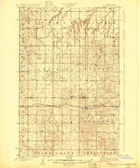
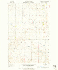
 1929 Kongsberg1929 Print · USGSThe North Dakota prairie near the McHenry and McLean county line is shown here in the late twenties as a network of rail-bound villages and rural schools. You can trace the Soo Line railroad to Kongsberg or locate family-named landmarks like Woodhill Sch and Dogden Butte.2 unique versions available
 - 1929 Map of Balfour
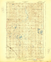
 1929 Balfour1929 Print · USGSNorth Dakota's central plains in the late twenties reveal a landscape of homesteads and rail towns along the Minneapolis St Paul and Sault Ste Marie. Genealogists can locate rural schoolhouses like Fleming School and trace the shores of Cottonwood Lake or Krueger Lake.
 - 1945 Map of Pelican Lake, 1955 Print
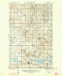
 1945 Pelican Lake1955 Print · USGSSheridan and McLean Counties in the mid-1940s reveal a landscape of prairie potholes and tightly-knit rural school districts. Genealogists can trace family footprints through numerous local schoolhouses and landmarks like Our Savior Cem and Immanuel Ch.3 unique versions available
 - 1947 Map of Pelican Lake
 1947 Pelican Lake1947 Print · USGSSheridan and McLean Counties in the mid-1940s are characterized by an intricate network of rural school districts and prairie lakes. Genealogists can trace family roots through numerous local landmarks like Immanuel Ch, Our Savior Cem, and Wise Sch No 1.
 - 1947 Map of Turtle Lake
 1947 Turtle Lake1947 Print · USGSMcLean County is captured here in the mid-1940s, showing a prairie landscape where the railroad and rural school districts defined the community. Genealogists can locate family landmarks like Medicine Hill Cem and numerous schoolhouses including Palmborg Sch No 1 and Aurena Sch No 1.
 - 1948 Map of Stanton, 1962 Print
 1948 Stanton1962 Print · USGSMid-century Mercer and McLean Counties are shown during the transformation of the Missouri River valley. Genealogists can locate family-named landmarks like Williams Sch, the Stanton Cem, and the historic Ft Clark (Site) near the Knife River confluence.
 - 1949 Map of Stanton
 1949 Stanton1949 Print · USGSThe Missouri River valley stands at the brink of transformation in the late 1940s as the massive Garrison Dam project begins near Riverdale. Researchers can trace the original river course and numerous family-named schools like Baisch Sch and Matton Sch alongside the Northern Pacific rail line.
 - 1949 Map of Turtle Creek
 1949 Turtle Creek1949 Print · USGSMcLean County townships are shown here in the late 1940s, highlighting a landscape of rural schools and prairie homesteads. Researchers can locate specific sites like Fairview Ch, Veeder Cem, and numerous schoolhouses including Satterlund Sch No 1.2 unique versions available
 - 1949 Map of Washburn
 1949 Washburn1949 Print · USGSMcLean County is captured here in the late 1940s as the river economy met the railroad age along the Missouri River. Family historians can trace numerous rural school sites like Weller School No 1 and the path of the Lewis and Clark Trail.2 unique versions available
 - 1950 Map of Wilton
 1950 Wilton1950 Print · USGSThe Missouri River breaks and upland prairies of McLean and Burleigh counties are mapped here at mid-century. Genealogists can locate family names via numerous rural landmarks, from Painted Woods Ch and Wing Cem to several local schoolhouses like School No 2.2 unique versions available
 - 1953 Map of Watford City, 1968 Print
 1953 Watford City1968 Print · USGSNorth Dakota's badlands and the Missouri River basin are captured here during the 1950s and 60s as the Garrison Dam changed the landscape. Researchers can trace old rail lines like the Great Northern or find rural outposts such as Grassy Butte and Halliday.3 unique versions available
 - 1954 Map of McClusky, 1968 Print
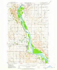
 1954 McClusky1968 Print · USGSCentral North Dakota was undergoing a profound transformation in the fifties as the newly formed Lake Sakakawea reshaped the Missouri River valley. Genealogists and historians can trace rail-town development along the Soo Line and locate historic markers like Garrison Dam or the Lewis and Clark Trail.3 unique versions available
 - 1956 Map of Makoti SW
 1956 Makoti SW1956 Print · USGSThe McLean and Mountrail county border in the mid-1950s is captured here, showing a landscape of prairie potholes and rural outposts. Researchers can locate family landmarks like the Bethlehem Ch, Roseglen Cem, and the Wright Sch.
 - 1956 Map of Blackwater Lake NW, 1957 Print
 1956 Blackwater Lake NW1957 Print · USGSNorth Dakota's high plains are documented here in the mid-fifties, capturing a landscape of remote farmsteads and tribal lands. Researchers can locate the Indian Scout Cem and trace the Ft Berthold Indian Reservation Boundary near School No 1.2 unique versions available
 - 1956 Map of Emmet NE, 1957 Print
 1956 Emmet NE1957 Print · USGSMid-century McLean County displays a transition in rural North Dakota as small school districts began to consolidate. Local historians can locate specific community landmarks like Banner Ch, Clifton Cem, and several schoolhouses including Platt Sch No 4.
 - 1956 Map of Blackwater Lake, 1957 Print
 1956 Blackwater Lake1957 Print · USGSMcLean County prairie land is captured here during the mid-fifties, showing the intersection of rural life and reservation boundaries. Researchers can trace the legacy of early education through several sites, including White Shield Sch and O'Shea Sch No 2.2 unique versions available
 - 1956 Map of Blue Hill, 1958 Print
 1956 Blue Hill1958 Print · USGSCentral North Dakota's prairie landscape is captured in the mid-fifties, showing the rural junction of Ward and McLean counties. Genealogists can locate family-named landmarks and local hubs like Blue Hill Sch and Centerville Sch.2 unique versions available
 - 1956 Map of Emmet, 1958 Print
 1956 Emmet1958 Print · USGSMcLean County is captured in the mid-1950s, showing a prairie landscape where small-town life and rural school districts remained the backbone of the community. Researchers can locate family-named sites such as Romaas Sch No 2, St Peters Ch, and the Clifton Cem.2 unique versions available
 - 1956 Map of Douglas West, 1958 Print
 1956 Douglas West1958 Print · USGSThe rural landscape between Ward and McLean County comes to life in the mid-1950s, centered on the rail-linked settlement of Douglas. Researchers can trace the path of the Soo Line and locate landmark sites like School No 4 and the heights of Blue Hill.
 - 1956 Map of Roseglen, 1958 Print
 1956 Roseglen1958 Print · USGSMcLean County in the mid-fifties presents a quiet landscape of prairie townships and conservation land. Genealogists and historians can trace the rural school system and the Old Indian Boundary near Roseglen and the Hiddenwood Cem.2 unique versions available
 - 1957 Map of Watford City
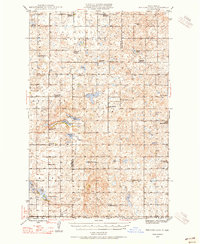
 1957 Watford City1957 Print · USGSWestern North Dakota's landscape is captured here during the mid-fifties as the Missouri River valley undergoes massive change following the creation of Garrison Reservoir. Genealogists and historians can trace dozens of rural schools like Divide School and early settlements such as Arnegard and Grassy Butte.
 - 1958 Map of McClusky
 1958 McClusky1958 Print · USGSCentral North Dakota was undergoing a profound change in the late fifties as the Garrison Reservoir filled behind its massive new dam. Trace the early layout of Riverdale, the Lewis and Clark Trail, and the vanishing rail stops of the Northern Pacific.
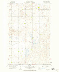
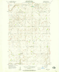
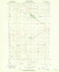
Showing maps 1-25 of 419
Top cities of McLean County
- Washburn historical maps
- Garrison historical maps
- Underwood historical maps
- Turtle Lake historical maps
- Riverdale historical maps
- Max historical maps
See more
Frequently asked questions
- What are the different types of historical maps available for McLean County?
- What is the oldest map of McLean County?
- Where can I purchase historical maps of McLean County for my home or office?
- Where can I download high-res historical maps of McLean County?
- Are there historical topographic maps available for McLean County?
- Is there historical aerial imagery available for McLean County?
- Where are historical maps of McLean County sourced from?