1940s Maps of McLean County, North Dakota
Explore 7 historic maps of McLean County from the 1940s. These maps offer a rare glimpse into what life looked like during the 1940s — showing old roads, neighborhoods, homes, and landmarks that have changed or disappeared over time.
Whether you're researching your family's past, planning a metal detecting trip, or studying how McLean County's landscape evolved across the 1940s, these high-resolution maps are a powerful tool for exploring the history of this region.
- Focus on a specific era: All maps on this page are from the 1940s, giving you a focused view of this time period.
- See what’s changed: Compare century-old streets, trails, and buildings to today's modern landscape using overlays and satellite layers.
- Research with precision: Use these maps for genealogy, historical research, land use analysis, or educational projects.
- View, download, or print: Maps are fully viewable online in high resolution, and can be downloaded or printed for your own records.
Start exploring McLean County's history through authentic maps from the 1940s. This is your window into the past.
McLean County, ND maps
(7)- 1945 Map of Pelican Lake, 1955 Print
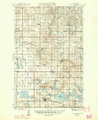
 1945 Pelican Lake1955 Print · USGSSheridan and McLean Counties in the mid-1940s reveal a landscape of prairie potholes and tightly-knit rural school districts. Genealogists can trace family footprints through numerous local schoolhouses and landmarks like Our Savior Cem and Immanuel Ch.3 unique versions available
 - 1947 Map of Pelican Lake
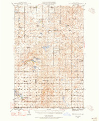
 1947 Pelican Lake1947 Print · USGSSheridan and McLean Counties in the mid-1940s are characterized by an intricate network of rural school districts and prairie lakes. Genealogists can trace family roots through numerous local landmarks like Immanuel Ch, Our Savior Cem, and Wise Sch No 1.
 - 1947 Map of Turtle Lake
 1947 Turtle Lake1947 Print · USGSMcLean County is captured here in the mid-1940s, showing a prairie landscape where the railroad and rural school districts defined the community. Genealogists can locate family landmarks like Medicine Hill Cem and numerous schoolhouses including Palmborg Sch No 1 and Aurena Sch No 1.
 - 1948 Map of Stanton, 1962 Print
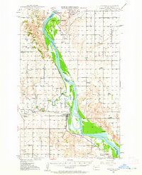 1948 Stanton1962 Print · USGSMid-century Mercer and McLean Counties are shown during the transformation of the Missouri River valley. Genealogists can locate family-named landmarks like Williams Sch, the Stanton Cem, and the historic Ft Clark (Site) near the Knife River confluence.
 - 1949 Map of Stanton
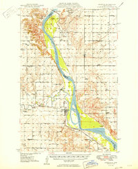 1949 Stanton1949 Print · USGSThe Missouri River valley stands at the brink of transformation in the late 1940s as the massive Garrison Dam project begins near Riverdale. Researchers can trace the original river course and numerous family-named schools like Baisch Sch and Matton Sch alongside the Northern Pacific rail line.
 - 1949 Map of Turtle Creek
 1949 Turtle Creek1949 Print · USGSMcLean County townships are shown here in the late 1940s, highlighting a landscape of rural schools and prairie homesteads. Researchers can locate specific sites like Fairview Ch, Veeder Cem, and numerous schoolhouses including Satterlund Sch No 1.2 unique versions available
 - 1949 Map of Washburn
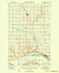 1949 Washburn1949 Print · USGSMcLean County is captured here in the late 1940s as the river economy met the railroad age along the Missouri River. Family historians can trace numerous rural school sites like Weller School No 1 and the path of the Lewis and Clark Trail.2 unique versions available
End of results
Showing maps 1-7 of 7
Top cities of McLean County
- Washburn historical maps
- Garrison historical maps
- Underwood historical maps
- Turtle Lake historical maps
- Riverdale historical maps
- Max historical maps
See more
Frequently asked questions
- What are the different types of historical maps available for McLean County?
- What is the oldest map of McLean County?
- Where can I purchase historical maps of McLean County for my home or office?
- Where can I download high-res historical maps of McLean County?
- Are there historical topographic maps available for McLean County?
- Is there historical aerial imagery available for McLean County?
- Where are historical maps of McLean County sourced from?