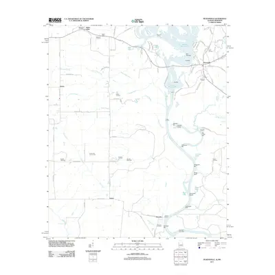
2011 Map of Pickensville
USGS Topo · Published 2011About this map
The Tombigbee River snakes through this landscape on the Alabama-Mississippi border, its course defined by numerous sandbars and shoals that shaped river navigation for generations. Along its banks, features like Shylock Shoals, Turnipseed Shoals, and Carraways Bluff anchor the geography. The settlement of Pickensville sits at a strategic bend, served by the Lower Cemetery and Saint John Cemetery. Further inland, the small communities of Bigbee Valley, Aubrey, and Memphis maintain their distinct identities through local landmarks like the Bigbee Valley Post Office and various family burial grounds including Roberson Cemetery and Brewer Cemetery. The intricate network of waterways, including Indian Camp Creek and Cypress Branch, feeds into the main river channel, while numerous cutoffs like Hairston Bend Cutoff illustrate the river's historical shifts and modern management.
Find a feature on this map
98 named features on this map. Tap any name to fly to it.
Don’t see what you’re looking for? This feature index may not catch every label — zoom into the map to look around manually.
Map Details
Editions of this 2011 Pickensville Map
This is the sole edition of this map. No revisions or reprints were ever made.
Other maps of this area

1953 · West Point
USGS Topo · 1:250,000

1958 · West Point
USGS Topo · 1:250,000

1960 · Columbus
USGS Topo · 1:62,500

1963 · West Point
USGS Topo · 1:250,000

1966 · Reform SW
USGS Topo · 1:24,000

1970 · Aliceville North
USGS Topo · 1:24,000

1970 · Aliceville South
USGS Topo · 1:24,000

1973 · Cliftonville
USGS Topo · 1:24,000

1973 · McLeod
USGS Topo · 1:24,000
1974 · Dancy
USGS Topo · 1:24,000