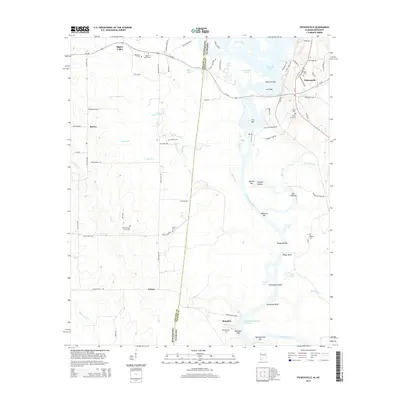
2014 Map of Pickensville
USGS Topo · Published 2014About this map
The Tombigbee River and the modern Tennessee-Tombigbee Waterway define the borderlands between Alabama and Mississippi in this detailed 2014 study. The town of Pickensville serves as a focal point near Aliceville Lake, while the smaller settlement of Memphis sits further south along the river. This river-valley landscape is marked by a high density of historic cemeteries, including Saint John Cem, Bigbee Valley Cem, and Memphis Cem, offering significant value for genealogists tracing families in Pickens County and Noxubee County.
Find a feature on this map
85 named features on this map. Tap any name to fly to it.
Don’t see what you’re looking for? This feature index may not catch every label — zoom into the map to look around manually.
Map Details
Editions of this 2014 Pickensville Map
This is the sole edition of this map. No revisions or reprints were ever made.
Other maps of this area

1953 · West Point
USGS Topo · 1:250,000

1958 · West Point
USGS Topo · 1:250,000

1960 · Columbus
USGS Topo · 1:62,500

1963 · West Point
USGS Topo · 1:250,000

1966 · Reform SW
USGS Topo · 1:24,000

1970 · Aliceville North
USGS Topo · 1:24,000

1970 · Aliceville South
USGS Topo · 1:24,000

1973 · Cliftonville
USGS Topo · 1:24,000

1973 · McLeod
USGS Topo · 1:24,000
1974 · Dancy
USGS Topo · 1:24,000