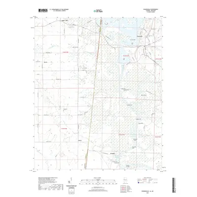
2020 Map of Pickensville
USGS Topo · Published 2020About this map
The Tombigbee River forms the central spine of this landscape at the Mississippi-Alabama border, dominated by the engineering of the Tennessee-Tombigbee Waterway. The river is marked by numerous bars and shoals, including Shylock Shoals and Turnipseed Shoals, alongside modern features like Aliceville Lake and the Pickensville Cut Off. Historically significant settlements and small rural communities anchor the upland areas.
Find a feature on this map
109 named features on this map. Tap any name to fly to it.
Don’t see what you’re looking for? This feature index may not catch every label — zoom into the map to look around manually.
Map Details
Editions of this 2020 Pickensville Map
This is the sole edition of this map. No revisions or reprints were ever made.
Other maps of this area

1953 · West Point
USGS Topo · 1:250,000

1958 · West Point
USGS Topo · 1:250,000

1960 · Columbus
USGS Topo · 1:62,500

1963 · West Point
USGS Topo · 1:250,000

1966 · Reform SW
USGS Topo · 1:24,000

1970 · Aliceville North
USGS Topo · 1:24,000

1970 · Aliceville South
USGS Topo · 1:24,000

1973 · Cliftonville
USGS Topo · 1:24,000

1973 · McLeod
USGS Topo · 1:24,000
1974 · Dancy
USGS Topo · 1:24,000