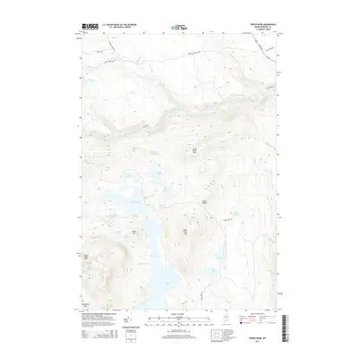
2014 Map of Pierce Pond
USGS Topo · Published 2014About this map
Pierce Pond dominates this Somerset County landscape, defined by a chain of water bodies and dramatic elevation changes in the Maine woods. The central water complex features the constricted Caribou Narrows, which connects the larger basin of Pierce Pond to Upper Pierce Pond and a network of smaller waters including Split Rock Pond and Horseshoe Pond. High peaks surround the drainage basins, notably Dead River Mtn and Black Nubble, while the Dead River carves a path through the northern half of the quadrangle. Transport in the early 21st century is represented by the corridor of Us-201 in the northeast, contrasted with timber and access routes like Upper Enchanted Rd and Lower Enchanted Rd. The map documents a classic North Woods landscape of interconnected streams like Gulf Stream and Salmon Stream that feed into the region's prominent lakes and river systems.
Find a feature on this map
41 named features on this map. Tap any name to fly to it.
Don’t see what you’re looking for? This feature index may not catch every label — zoom into the map to look around manually.
Map Details
Editions of this 2014 Pierce Pond Map
This is the sole edition of this map. No revisions or reprints were ever made.
Other maps of this area

1903 · Bingham
USGS Topo · 1:62,500

1905 · Bingham
USGS Topo · 1:62,500

1905 · The Forks
USGS Topo · 1:62,500

1907 · The Forks
USGS Topo · 1:62,500

1925 · Pierce Pond
USGS Topo · 1:48,000

1927 · Pierce Pond
USGS Topo · 1:62,500

1928 · Dead River
USGS Topo · 1:62,500

1931 · Dead River
USGS Topo · 1:48,000

1944 · Dead River
USGS Topo · 1:62,500

1944 · Pierce Pond
USGS Topo · 1:62,500
Featured Places
- West Forks, ME
- Bowtown Township, ME
- Pierce Pond Township, ME
- Lower Enchanted Township, ME
- Somerset County, ME