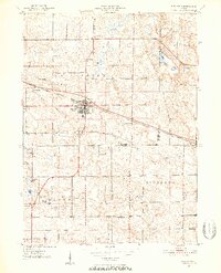
1950 Map of Pierceton
USGS Topo · Published 1952About this map
The town of Pierceton serves as the focal point of this mid-century survey, situated at the intersection of critical regional transport lines where the Pennsylvania railroad meets local thoroughfares. The landscape is characterized by a dense concentration of small glacial lakes, including Mud Lake, Robinson Lake, and Larrew Lake, which are interspersed among the rectangular grid of rural sections. This pattern of land use reveals a mature agricultural society in Washington, Troy, and Richland townships, where the presence of the Consolidated Sch and several country houses of worship like Wooster Ch and Boonesville Ch indicate established community nodes outside the primary settlements. To the east, the village of Larwill anchors the edge of Whitley Co, while smaller named points like Deeds reflect the localized geography of the era. Genealogists will find several burial grounds mapped in detail, including Hillcrest Cem and the Richland Center Cem.
Find a feature on this map
28 named features on this map. Tap any name to fly to it.
Don’t see what you’re looking for? This feature index may not catch every label — zoom into the map to look around manually.
Map Details
Editions of this 1950 Pierceton Map
2 editions found
Other maps of this area

1950 · Leesburg
USGS Topo · 1:24,000

1950 · Pierceton
USGS Topo · 1:24,000

1950 · North Webster
USGS Topo · 1:24,000

1951 · Ormas
USGS Topo · 1:24,000

1953 · Fort Wayne
USGS Topo · 1:250,000

1956 · Fort Wayne
USGS Topo · 1:250,000

1956 · Lorane
USGS Topo · 1:24,000

1957 · Warsaw
USGS Topo · 1:24,000
1962 · North Manchester North
USGS Topo · 1:24,000
1962 · South Whitley West
USGS Topo · 1:24,000