
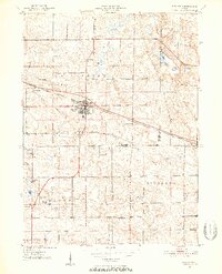
1950 Map of Pierceton
USGS Topo · Published 1952About this map
Pierceton serves as the central hub of this Indiana landscape, situated along the Pennsylvania railroad line that cuts a straight path across the terrain. The map captures the agricultural and community structure of the early 1950s, where small settlements like Larwill and Deeds are anchored by local institutions such as Wooster Church and the Consolidated School. A dense concentration of small glacial lakes, including Robinson Lake, Sellers Lake, and Mud Lake, dot the townships, shaping the local geography between Washington, Troy, and Richland. For those looking into local history, the distribution of burial sites like Washington-Union Cemetery and Hillcrest Cemetery provides a clear view of the area's rural social fabric during this post-war era.
Find a feature on this map
30 named features on this map. Tap any name to fly to it.
Don’t see what you’re looking for? This feature index may not catch every label — zoom into the map to look around manually.
Map Details
Editions of this 1950 Pierceton Map
2 editions found
Other maps of this area

1950 · Leesburg
USGS Topo · 1:24,000

1950 · North Webster
USGS Topo · 1:24,000

1951 · Ormas
USGS Topo · 1:24,000

1953 · Fort Wayne
USGS Topo · 1:250,000

1956 · Fort Wayne
USGS Topo · 1:250,000

1956 · Lorane
USGS Topo · 1:24,000

1957 · Warsaw
USGS Topo · 1:24,000
1962 · North Manchester North
USGS Topo · 1:24,000
1962 · South Whitley West
USGS Topo · 1:24,000
1962 · South Whitley East
USGS Topo · 1:24,000