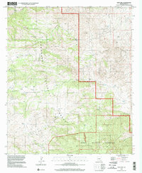
1996 Map of Piety Hill
USGS Topo · Published 2002About this map
Coronado National Forest and the Rincon Mountain Wilderness dominate this high-desert landscape in Pima County, where cattle ranching and water management define the local geography. The map reveals a complex network of man-made water features essential for survival in this arid environment, including the Youtcy Pasture Tank, Italian Trap Tank, and Josephine Tank. These reservoirs, paired with natural sources like Alamo Spring and Bullock Spring, illustrate the infrastructure required to support livestock across the canyons.
Find a feature on this map
45 named features on this map. Tap any name to fly to it.
Don’t see what you’re looking for? This feature index may not catch every label — zoom into the map to look around manually.
Map Details
Editions of this 1996 Piety Hill Map
This is the sole edition of this map. No revisions or reprints were ever made.
Other maps of this area

1904 · Tucson
USGS Topo · 1:125,000

1905 · Tucson
USGS Topo · 1:125,000

1945 · Redington
USGS Topo · 1:62,500

1945 · Happy Valley
USGS Topo · 1:62,500

1956 · Tucson
USGS Topo · 1:250,000

1957 · Bellota Ranch
USGS Topo · 1:62,500

1957 · Rincon Valley
USGS Topo · 1:62,500

1957 · Redington
USGS Topo · 1:62,500

1958 · Tucson
USGS Topo · 1:250,000

1958 · Happy Valley
USGS Topo · 1:62,500