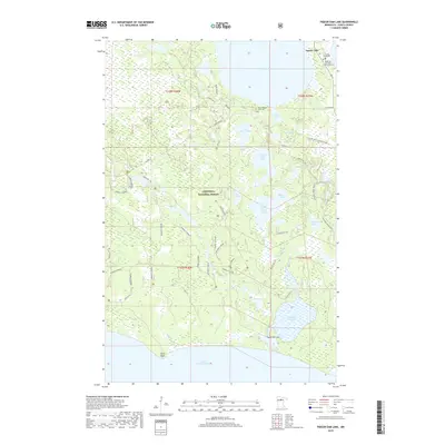
2019 Map of Pigeon Dam Lake
USGS Topo · Published 2019About this map
Chippewa National Forest surrounds a complex network of waterways in northern Itasca County, where the Pigeon River flows between a chain of lakes. The settlement of Squaw Lake sits in the northeast corner, serving as a gateway to the region's expansive timber and recreation lands. This landscape is defined by its glacial history, evidenced by the cluster of interconnected basins including Upper Pigeon Lake, Middle Pigeon Lake, and Lower Pigeon Lake. Local history is anchored by the Squaw Lake Cem and the Peter and Eva Niska Memorial Cem, while the southern edge of the sheet opens onto the massive expanse of Lake Winnibigoshish. Long-distance recreational routes like the Cut Foot Sioux N R T and Cutfoot Horse Trail traverse the wooded terrain, reflecting the modern management of these traditional Northwoods forest lands.
Find a feature on this map
43 named features on this map. Tap any name to fly to it.
Don’t see what you’re looking for? This feature index may not catch every label — zoom into the map to look around manually.
Map Details
Editions of this 2019 Pigeon Dam Lake Map
This is the sole edition of this map. No revisions or reprints were ever made.
Other maps of this area

1919 · Rosy
USGS Topo · 1:62,500

1919 · Max
USGS Topo · 1:62,500

1954 · Bemidji
USGS Topo · 1:250,000

1957 · Bemidji
USGS Topo · 1:250,000

1958 · Bemidji
USGS Topo · 1:250,000

1971 · Squaw Lake
USGS Topo · 1:24,000

1971 · Dixon Lake
USGS Topo · 1:24,000

1971 · Raven Lake
USGS Topo · 1:24,000
1971 · Dora Lake
USGS Topo · 1:24,000
1971 · Max
USGS Topo · 1:24,000