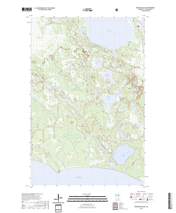
2023 Map of Pigeon Dam Lake
USGS Topo · Published 2023About this map
Chippewa National Forest surrounds a complex aquatic network in northern Minnesota, defined by the cascading chain of Upper Pigeon Lake, Middle Pigeon Lake, and Lower Pigeon Lake. This landscape is fundamentally shaped by the Pigeon River drainage and the northern reaches of Lake Winnibigoshish at Stony Point. The map documents a terrain saturated with small glacial lakes such as Alice Lake, Virgin Lake, and Mosomo Lake, many of which are connected by a dense system of specialized paths, including the Cutfoot Sioux National Recreation Tr and the Winnie North Hiking A Trl. Cultural landmarks are few in this timbered expanse, with the South Round Lake Cem standing as a significant genealogical marker near the shores of Round Lake. The distribution of forest roads like Co Hwy 33 and Virgin Lake Rd illustrates the transition from public recreation to managed forest resources.
Find a feature on this map
58 named features on this map. Tap any name to fly to it.
Don’t see what you’re looking for? This feature index may not catch every label — zoom into the map to look around manually.
Map Details
Editions of this 2023 Pigeon Dam Lake Map
This is the sole edition of this map. No revisions or reprints were ever made.
Other maps of this area

1919 · Rosy
USGS Topo · 1:62,500

1919 · Max
USGS Topo · 1:62,500

1954 · Bemidji
USGS Topo · 1:250,000

1957 · Bemidji
USGS Topo · 1:250,000

1958 · Bemidji
USGS Topo · 1:250,000

1971 · Squaw Lake
USGS Topo · 1:24,000

1971 · Dixon Lake
USGS Topo · 1:24,000

1971 · Raven Lake
USGS Topo · 1:24,000
1971 · Dora Lake
USGS Topo · 1:24,000
1971 · Max
USGS Topo · 1:24,000