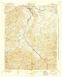
1940 Map of Pigeon Forge
USGS Topo · Published 1940About this map
Sevierville and the emerging community of Pigeon Forge serve as the primary hubs in this 1940 preliminary survey of the Tennessee Valley. The landscape is defined by the convergence of the Middle Fork Little Pigeon River and the West Fork Little Pigeon River, creating a fertile valley floor between high points like Shields Mtn and Pine Mountain. Transportation and industry are evolving here, evidenced by the Chapman Highway and a Power Plant near the river fork. Rural life is well-documented through numerous schools and churches, including Williamsburg Sch and Marshall Grove Ch. Family histories are preserved in landmarks like the Mc Mahan Cem and the County Home near the river, while natural features like Large Ford and Goose Gap highlight the traditional routes used to navigate the Sevier County terrain before modern infrastructure was fully established.
Find a feature on this map
59 named features on this map. Tap any name to fly to it.
Don’t see what you’re looking for? This feature index may not catch every label — zoom into the map to look around manually.
Map Details
Editions of this 1940 Pigeon Forge Map
This is the sole edition of this map. No revisions or reprints were ever made.
Other maps of this area

1886 · Knoxville
USGS Topo · 1:125,000

1892 · Knoxville
USGS Topo · 1:125,000

1893 · Mt Guyot
USGS Topo · 1:125,000

1894 · Knoxville
USGS Topo · 1:125,000

1895 · Knoxville
USGS Topo · 1:125,000

1901 · Knoxville
USGS Topo · 1:125,000

1912 · Mt Guyot
USGS Topo · 1:125,000

1935 · English Mountain
USGS Topo · 1:48,000

1935 · Walden Creek
USGS Topo · 1:24,000

1935 · Richardson Cove
USGS Topo · 1:24,000