Loading...
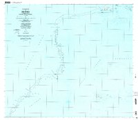
Loading map...1997 Map of Piis Moen
USGS Topo · Published 2004About this map
Piis Moen sits at the northern edge of the Chuuk Lagoon, defining a narrow arc of land between the interior waters and the open Pacific Ocean. This survey reveals a traditional settlement pattern concentrated on the eastern headland, where clusters like Nukan, Senipeu, and Sapatio are situated. The map illustrates how life on the atoll is closely tied to the water, with numerous named channels and reef features such as Mochun Pisininin and Mochonap marking the maritime boundaries.
Find a feature on this map
54 named features on this map. Tap any name to fly to it.
Don’t see what you’re looking for? This feature index may not catch every label — zoom into the map to look around manually.
Map Details
Date Portrayed1997
Date Published2004
PublisherU.S. Geological Survey
Map TypeTopographic
Scale1:25,000
Physical Dimensions39.1 x 34 inches
Editions of this 1997 Piis Moen Map
This is the sole edition of this map. No revisions or reprints were ever made.
Other maps of this area
Featured Places
Source Details
SourceU.S. Geological Survey
CopyrightPublic Domain