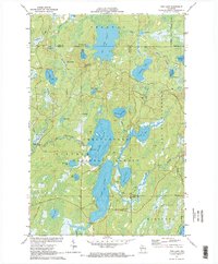
1971 Map of Pike Lake
USGS Topo · Published 1973About this map
The Chequamegon National Forest defines this lake-studded landscape in northern Wisconsin, where the Price, Iron, Vilas, and Oneida county lines converge. The central water system is dominated by the chain of Pike Lake, Round Lake, and Big Pine Lake, which connect to the South Fork Flambeau River. In 1971, the area shows signs of recreation and forestry management, including the Fishtrap Campground and the Lookout Tower at Sentinel Point. The eastern edge of the survey is bounded by the Lac du Flambeau Indian Reservation Boundary, while the Chippewa Trail provides a historical terrestrial route through the dense network of small water bodies like Apeekwa Lake and Amik Lake. This survey is particularly useful for identifying the specific lake depths and drainage patterns before later development altered these Northwoods shorelines.
Find a feature on this map
51 named features on this map. Tap any name to fly to it.
Don’t see what you’re looking for? This feature index may not catch every label — zoom into the map to look around manually.
Map Details
Editions of this 1971 Pike Lake Map
This is the sole edition of this map. No revisions or reprints were ever made.
Other maps of this area

1938 · Lac Du Flambeau
USGS Topo · 1:48,000

1939 · Lac Du Flambeau
USGS Topo · 1:48,000

1939 · Winchester
USGS Topo · 1:48,000

1940 · Mercer
USGS Topo · 1:48,000

1941 · Pike Lake
USGS Topo · 1:48,000

1942 · Pike Lake
USGS Topo · 1:48,000

1945 · Mercer
USGS Topo · 1:48,000

1946 · Winchester
USGS Topo · 1:48,000

1946 · Lac Du Flambeau
USGS Topo · 1:48,000

1947 · Mercer
USGS Topo · 1:48,000