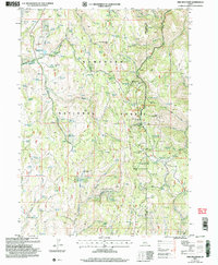
2001 Map of Pike Mountain
USGS Topo · Published 2006About this map
The Sawtooth National Forest high country along the Twin Falls and Cassia county line is defined here by a network of seasonal camps, spring-fed drainages, and recreational infrastructure. A historical layer of human presence is visible at the Historic Shoshone Cabin Site and nearby Shoshone Cabin, while the modern era of outdoor leisure is represented by the Magic Mountain Ski Area and various retreat sites. The landscape is dotted with named camps such as Kum Ba Yah Camp, Tawakani Camp, and the Pinedale Lodge Organization Camp. Water resources are central to the terrain's utility, evidenced by dozens of named springs like Blue Mud Spring and the Shoshone Basin Wildlife Pond. Development is concentrated along Deadline Ridge, where the Deadline Summer Homes Area and Balsam Summer Homes Area sit near Pike Mountain.
Find a feature on this map
79 named features on this map. Tap any name to fly to it.
Don’t see what you’re looking for? This feature index may not catch every label — zoom into the map to look around manually.
Map Details
Editions of this 2001 Pike Mountain Map
This is the sole edition of this map. No revisions or reprints were ever made.
Other maps of this area

1955 · Twin Falls
USGS Topo · 1:250,000

1958 · Twin Falls
USGS Topo · 1:250,000

1965 · Rams Horn Ridge
USGS Topo · 1:24,000

1965 · Grand View Peak
USGS Topo · 1:24,000

1965 · Mc Mullen Basin
USGS Topo · 1:24,000

1977 · Timber Butte
USGS Topo · 1:24,000

1977 · Big Creek Ranch
USGS Topo · 1:24,000

1977 · Mahogany Butte
USGS Topo · 1:24,000

1978 · Hopper Gulch
USGS Topo · 1:24,000
1978 · Pike Mountain
USGS Topo · 1:24,000