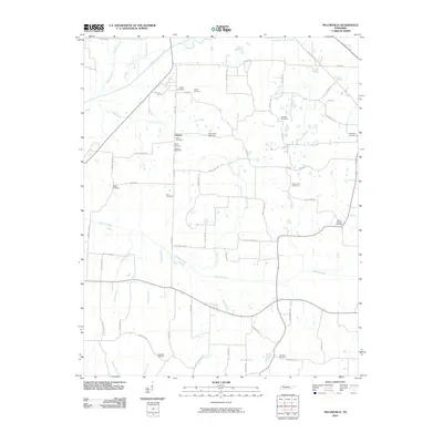
2010 Map of Pillowville
USGS Topo · Published 2010About this map
The Middle Fork Obion River meanders across the northern edge of this West Tennessee landscape, defining a terrain shaped by numerous small tributaries like Cane Creek and Cotton Creek. The small settlement of Liberty serves as a central point for a community long tied to the land, evidenced by the dense concentration of family and community burial grounds throughout the quadrangle. Genealogists will find a wealth of specific locations including Liberty Cemetery, Parks Cemetery, and the Edmoniston Cemetery. The road network, including names like Caudle Store Rd and Staffords Store Rd, reflects a rural economy built around local commerce and farming. The southern reaches are drained by Manus Creek and Spring Creek, where Seminary Cemetery and Meridian Cemetery mark early gathering places in Weakley County.
Find a feature on this map
58 named features on this map. Tap any name to fly to it.
Don’t see what you’re looking for? This feature index may not catch every label — zoom into the map to look around manually.
Map Details
Editions of this 2010 Pillowville Map
This is the sole edition of this map. No revisions or reprints were ever made.
Other maps of this area

1950 · Martin
USGS Topo · 1:24,000

1952 · Dresden
USGS Topo · 1:24,000

1954 · Greenfield
USGS Topo · 1:24,000

1954 · Bradford
USGS Topo · 1:24,000

1956 · Dyersburg
USGS Topo · 1:250,000

1957 · Como
USGS Topo · 1:24,000

1966 · Trezevant West
USGS Topo · 1:24,000

1967 · Pillowville
USGS Topo · 1:24,000
1967 · Trezevant East
USGS Topo · 1:24,000
1967 · Mc Kenzie
USGS Topo · 1:24,000