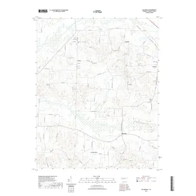
2019 Map of Pillowville
USGS Topo · Published 2019About this map
The Middle Fork Obion River and its numerous tributaries, including Cane Cr and Spring Cr, define the drainage patterns of this rural Weakley County landscape. In the southern reaches, Pillowville and Crowley Store serve as local landmarks along a network of backroads like the Pillowville Gleason Rd. The region is densely populated with family and community burial sites, many associated with the early settlements of Liberty and Sandhill. These features, such as the Edmonston Cem and Simms Cem, offer significant geographic context for genealogical research. The presence of numerous named branches like Terrell Br and Garner Br highlights the intricate hydrology that influenced the placement of original farmsteads and rural churches across these bottomlands.
Find a feature on this map
93 named features on this map. Tap any name to fly to it.
Don’t see what you’re looking for? This feature index may not catch every label — zoom into the map to look around manually.
Map Details
Editions of this 2019 Pillowville Map
This is the sole edition of this map. No revisions or reprints were ever made.
Other maps of this area

1950 · Martin
USGS Topo · 1:24,000

1952 · Dresden
USGS Topo · 1:24,000

1954 · Greenfield
USGS Topo · 1:24,000

1954 · Bradford
USGS Topo · 1:24,000

1956 · Dyersburg
USGS Topo · 1:250,000

1957 · Como
USGS Topo · 1:24,000

1966 · Trezevant West
USGS Topo · 1:24,000

1967 · Pillowville
USGS Topo · 1:24,000
1967 · Trezevant East
USGS Topo · 1:24,000
1967 · Mc Kenzie
USGS Topo · 1:24,000