1964 Map of Pilot Mountain
USGS Topo · Published 1965About this map
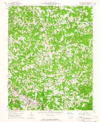
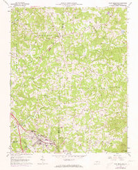
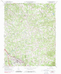
The boundary between Surry Co and Stokes Co bisects this mid-1960s landscape, centered on the landmark town of Pilot Mountain. The town serves as a hub for the southern portion of the map, situated along the Southern railroad line and supported by municipal infrastructure like the Pilot Mountain Filtration Plant. To the north, the community of Westfield sits at the junction of several rural routes including Westfield Road and Dearman Road, serving a countryside defined by deep agricultural and family ties. This history is preserved in a dense network of small family burial grounds and community churches, such as Toms Creek Ch, Jessup Grove Ch, and the Venable Cem. The terrain transitions from the rolling hills of Quaker Gap toward the distinct rise of Sauratown Mtn in the southeast, while numerous watercourses like Toms Creek and Big Creek drain the surrounding valley.
Find a feature on this map
54 named features on this map. Tap any name to fly to it.
Don’t see what you’re looking for? This feature index may not catch every label — zoom into the map to look around manually.
Map Details
Editions of this 1964 Pilot Mountain Map
3 editions found
Other maps of this area

1889 · Hillsville
USGS Topo · 1:125,000

1891 · Yadkinville
USGS Topo · 1:125,000

1892 · Hillsville
USGS Topo · 1:125,000

1893 · Yadkinville
USGS Topo · 1:125,000

1896 · Hillsville
USGS Topo · 1:125,000

1928 · Stuart
USGS Topo · 1:48,000

1931 · Stuart
USGS Topo · 1:62,500

1953 · Winston-Salem
USGS Topo · 1:250,000

1955 · Winston-Salem
USGS Topo · 1:250,000

1957 · Mount Airy
USGS Topo · 1:62,500