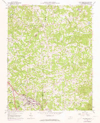
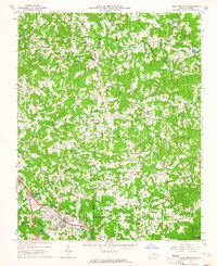
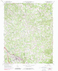
1964 Map of Pilot Mountain
USGS Topo · Published 1973About this map
Pilot Mountain serves as the focal point for this survey of the Piedmont region, where the town transitions into the rising elevations of Sauratown Mtn and Quaker Gap. The landscape is a network of small family farming communities and spiritual centers, such as Locust Grove Ch, Toms Creek Ch, and Jessup Grove Ch. Many of these settlements are identified by familial cemeteries including the Bill France Stand Cem, Venable Cem, and Beasley Cem, providing a detailed record for genealogical research.
Find a feature on this map
47 named features on this map. Tap any name to fly to it.
Don’t see what you’re looking for? This feature index may not catch every label — zoom into the map to look around manually.
Map Details
Editions of this 1964 Pilot Mountain Map
3 editions found
Other maps of this area

1889 · Hillsville
USGS Topo · 1:125,000

1891 · Yadkinville
USGS Topo · 1:125,000

1892 · Hillsville
USGS Topo · 1:125,000

1893 · Yadkinville
USGS Topo · 1:125,000

1896 · Hillsville
USGS Topo · 1:125,000

1928 · Stuart
USGS Topo · 1:48,000

1931 · Stuart
USGS Topo · 1:62,500

1953 · Winston-Salem
USGS Topo · 1:250,000

1955 · Winston-Salem
USGS Topo · 1:250,000

1957 · Mount Airy
USGS Topo · 1:62,500