
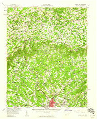
1957 Map of Mount Airy
USGS Topo · Published 1959About this map
Mount Airy sits at the foot of the Blue Ridge, anchoring a landscape where the North Carolina Piedmont meets the rising Virginia highlands. The city center is marked by mid-century infrastructure, including a Filtration Plant, a Standpipe, and the Radio Tower (WPAQ) perched near the Ararat River. To the south, the Drive-in Theater reflects the era's emerging car culture, while the northern terrain climbs sharply toward the Blue Ridge Parkway. The map reveals a dense network of mountain communities like Gladesboro and Fancy Gap, connected by winding roads and numerous rural institutions such as the Blue Ridge Tabernacle and Sunnyside Sch. Geologic interest is signaled by scattered Mine and Quarry sites throughout the hills. This survey details the transition from the industrial and commercial hub of Surry County into the agricultural and wooded reaches of Carroll and Patrick Counties.
Find a feature on this map
109 named features on this map. Tap any name to fly to it.
Don’t see what you’re looking for? This feature index may not catch every label — zoom into the map to look around manually.
Map Details
Editions of this 1957 Mount Airy Map
2 editions found
Other maps of this area

1889 · Hillsville
USGS Topo · 1:125,000

1891 · Yadkinville
USGS Topo · 1:125,000

1892 · Hillsville
USGS Topo · 1:125,000

1893 · Yadkinville
USGS Topo · 1:125,000

1896 · Hillsville
USGS Topo · 1:125,000

1928 · Stuart
USGS Topo · 1:48,000

1930 · Max Meadows
USGS Topo · 1:62,500

1931 · Stuart
USGS Topo · 1:62,500

1931 · Galax
USGS Topo · 1:48,000

1933 · Galax
USGS Topo · 1:62,500