
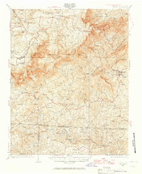
1928 Map of Stuart
USGS Topo · Published 1928About this map
Meadows of Dan and the settlement of Stuart anchor this late 1920s survey of the Blue Ridge foothills, where the Virginia North Carolina State Line divides Patrick County from Stokes County. The landscape is defined by the deep descent of the Dan River and Smith River, featuring dramatic landmarks like the Pinnacles of Dan and Great Falls of Dan. This era shows a densely populated rural backcountry, evidenced by the high frequency of local institutions such as the Stonewall Jackson School and Greaseys Chapel. A water-powered economy is still visible through the numerous milling operations scattered along the creeks, including Carters Mill, Brims Mill, and Three Forks Mill. The map documents a transition in education and community life, with scattered schools like Black Jack School and Five Forks School serving isolated mountain hollows.
Find a feature on this map
89 named features on this map. Tap any name to fly to it.
Don’t see what you’re looking for? This feature index may not catch every label — zoom into the map to look around manually.
Map Details
Editions of this 1928 Stuart Map
2 editions found
Other maps of this area

1889 · Hillsville
USGS Topo · 1:125,000

1891 · Yadkinville
USGS Topo · 1:125,000

1892 · Hillsville
USGS Topo · 1:125,000

1893 · Yadkinville
USGS Topo · 1:125,000

1896 · Hillsville
USGS Topo · 1:125,000

1926 · Critz
USGS Topo · 1:48,000

1928 · Critz
USGS Topo · 1:62,500

1931 · Stuart
USGS Topo · 1:62,500

1953 · Winston-Salem
USGS Topo · 1:250,000

1955 · Winston-Salem
USGS Topo · 1:250,000