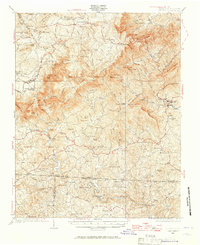
1928 Map of Stuart
USGS Topo · Published 1965About this map
The Knob and the striking Pinnacles of Dan define the dramatic topography of this Patrick County landscape, where the Blue Ridge drops toward the North Carolina border. The area is characterized by a high concentration of early 20th-century rural infrastructure, particularly a dense network of one-room schoolhouses like Mayberry Sch and Stonewall Jackson Sch. Small agricultural and milling communities are scattered throughout the drainages of the Dan River and Mayo River, with Carters Mills and Brims Mill serving as local hubs. The survey captures the early route of the Appalachian Trail and the Blue Ridge Trail before significant modern road development altered the access to remote landmarks like Lovers Leap and the Big Bend of Dan. This record preserved by Roscoe Reeves and his team highlights the intricate system of ridges and hollows, such as Sal Hooker Hollow, that dictated settlement patterns in the late 1920s.
Find a feature on this map
126 named features on this map. Tap any name to fly to it.
Don’t see what you’re looking for? This feature index may not catch every label — zoom into the map to look around manually.
Map Details
Editions of this 1928 Stuart Map
2 editions found
Other maps of this area

1889 · Hillsville
USGS Topo · 1:125,000

1891 · Yadkinville
USGS Topo · 1:125,000

1892 · Hillsville
USGS Topo · 1:125,000

1893 · Yadkinville
USGS Topo · 1:125,000

1896 · Hillsville
USGS Topo · 1:125,000

1926 · Critz
USGS Topo · 1:48,000

1928 · Stuart
USGS Topo · 1:48,000

1928 · Critz
USGS Topo · 1:62,500

1931 · Stuart
USGS Topo · 1:62,500

1953 · Winston-Salem
USGS Topo · 1:250,000