1964 Map of Pilot Mountain
USGS Topo · Published 1989About this map
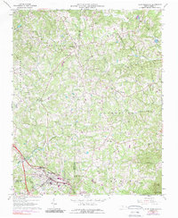
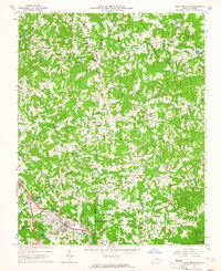
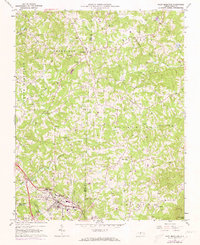
The town of Pilot Mountain anchors the southern portion of this landscape, situated along the Southern railway line and just north of the Yadkin River. The area is characterized by a dense network of family-named cemeteries and rural congregations, reflecting the deep-rooted community structure of Surry and Stokes counties. In the northern reaches, the settlement of Westfield sits near Meadow Branch, while the prominent peaks of Sauratown Mtn and the geological indentation of Quaker Gap define the eastern horizon.
Find a feature on this map
49 named features on this map. Tap any name to fly to it.
Don’t see what you’re looking for? This feature index may not catch every label — zoom into the map to look around manually.
Map Details
Editions of this 1964 Pilot Mountain Map
3 editions found
Other maps of this area

1889 · Hillsville
USGS Topo · 1:125,000

1891 · Yadkinville
USGS Topo · 1:125,000

1892 · Hillsville
USGS Topo · 1:125,000

1893 · Yadkinville
USGS Topo · 1:125,000

1896 · Hillsville
USGS Topo · 1:125,000

1928 · Stuart
USGS Topo · 1:48,000

1931 · Stuart
USGS Topo · 1:62,500

1953 · Winston-Salem
USGS Topo · 1:250,000

1955 · Winston-Salem
USGS Topo · 1:250,000

1957 · Mount Airy
USGS Topo · 1:62,500