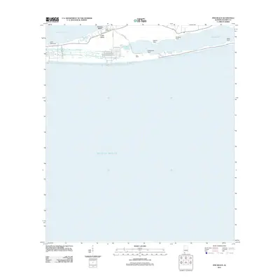
2011 Map of Pine Beach
USGS Topo · Published 2011About this map
Bon Secour Bay and the Gulf of Mexico define the narrow peninsula of this Baldwin County shoreline, where a network of coastal lakes and bayous creates a complex water-bound landscape. Early 21st-century residential developments like Palmetto Beach, Cedar Grove, and Pine Beach are shown laid out along the thin strip of land separating the bay from the gulf. The coastal geography is marked by several distinctive landforms, including Shell Banks and Edith Hammock to the west, and a series of points such as Eugene Point, Sheephead Point, and Childress Point that reach into the brackish waters. Transport through the area is anchored by Mobile St and Pine Beach Rd, which provide access to secluded water bodies like Gator Lake and the expansive Little Lagoon to the east.
Find a feature on this map
21 named features on this map. Tap any name to fly to it.
Don’t see what you’re looking for? This feature index may not catch every label — zoom into the map to look around manually.
Map Details
Editions of this 2011 Pine Beach Map
This is the sole edition of this map. No revisions or reprints were ever made.
Other maps of this area

1921 · Bon Secour
USGS Topo · 1:62,500

1921 · Point Clear
USGS Topo · 1:62,500

1941 · Foley
USGS Topo · 1:62,500

1941 · Weeks Bay
USGS Topo · 1:62,500

1943 · Weeks Bay
USGS Topo · 1:62,500

1943 · Foley
USGS Topo · 1:62,500

1957 · Pensacola
USGS Topo · 1:250,000

1959 · Pensacola
USGS Topo · 1:250,000

1960 · Pensacola
USGS Topo · 1:250,000
1978 · Pensacola
USGS Topo · 1:100,000