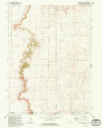
1991 Map of Pine Bluffs SE
USGS Topo · Published 1995About this map
Pine Bluffs provides the defining vertical relief for this tri-state corner, where the High Plains of Wyoming, Nebraska, and Colorado converge. The landscape is characterized by the stark escarpment of the bluffs themselves, which overlook the drainage of Muddy Creek and Spring Creek to the west. This 1991 inspection, based on earlier 1950s aerial photography, reveals a largely undeveloped ranching and resource territory. The map meticulously records the intersection of multiple county lines, including Laramie and Kimball counties at the state line. An industrial presence is marked by a long Pipeline cutting across the southern sections of the grid. In the central-eastern portion, the name Johnson is applied to a large expanse, likely signifying a significant historic ranching holding or a local land division in the Nebraska panhandle.
Find a feature on this map
11 named features on this map. Tap any name to fly to it.
Don’t see what you’re looking for? This feature index may not catch every label — zoom into the map to look around manually.
Map Details
Editions of this 1991 Pine Bluffs SE Map
This is the sole edition of this map. No revisions or reprints were ever made.
Other maps of this area

1954 · Sterling
USGS Topo · 1:250,000

1954 · Scottsbluff
USGS Topo · 1:250,000

1954 · Cheyenne
USGS Topo · 1:250,000

1954 · Greeley
USGS Topo · 1:250,000

1957 · Greeley
USGS Topo · 1:250,000

1958 · Cheyenne
USGS Topo · 1:250,000

1958 · Greeley
USGS Topo · 1:250,000

1958 · Scottsbluff
USGS Topo · 1:250,000

1958 · Sterling
USGS Topo · 1:250,000

1961 · Greeley
USGS Topo · 1:250,000