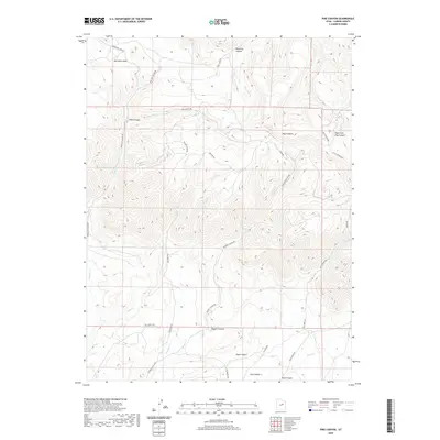
2020 Map of Pine Canyon
USGS Topo · Published 2020About this map
Whitmore Park and the rugged drainage systems of the Book Cliffs define this region of Carbon County, where a complex network of seasonal creeks has carved deep channels into the plateau. The landscape is dominated by expansive canyons, including Ninemile Canyon in the north and Dugout Canyon to the south. Historically significant access routes like Nine Mile Canyon Rd and Whitmore Park Rd follow these natural contours, providing passage through the dramatic elevation changes. A distinctive engineering feature, The Switch Backs, illustrates the challenge of traversing the steep terrain between Pine Canyon and the surrounding heights. In the southern portion of the map, the terrain opens into Clark Valley, where Dugout Cr and Pace Cr converge. This area is characterized by its remote ranching and transit corridors, including the primitive Fish Creek Jeep trail and the more established Dugout Canyon Rd.
Find a feature on this map
30 named features on this map. Tap any name to fly to it.
Don’t see what you’re looking for? This feature index may not catch every label — zoom into the map to look around manually.
Map Details
Editions of this 2020 Pine Canyon Map
This is the sole edition of this map. No revisions or reprints were ever made.
Other maps of this area

1886 · Price River
USGS Topo · 1:250,000

1896 · Price River
USGS Topo · 1:250,000

1915 · Sunnyside
USGS Topo · 1:62,500

1915 · Wellington
USGS Topo · 1:62,500

1956 · Price
USGS Topo · 1:250,000

1960 · Price
USGS Topo · 1:250,000

1962 · Price
USGS Topo · 1:250,000

1968 · Wood Canyon
USGS Topo · 1:24,000
1969 · Minnie Maud Creek East
USGS Topo · 1:24,000
1969 · Minnie Maud Creek West
USGS Topo · 1:24,000